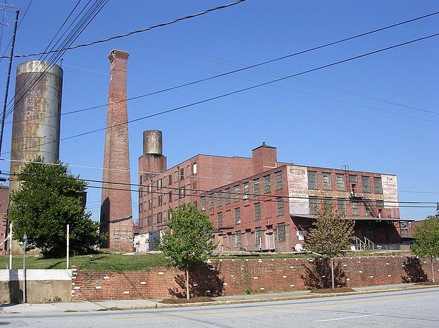
After taking photos around Cabbagetown on a beautiful January day in 1990, I spotted this interesting old warehouse at the intersection of Connally Street and MLK and snapped this photo through the windshield while at the stop sign. This was directly across MLK from what is now the City Limit Cafe and diagonally across the intersection from the now demolished Capitol Homes housing project.
Coincidentally, flickr photographer Amber Rhea took this photo from the same spot over 15 years later in October 2005. The warehouse had been demolished but the water tower, smokestack, and adjacent Atlanta Paper Company building were all still standing. It looked like this building might eventually be converted into lofts, but...
When I returned in February 2012 I was greeted by one of the most spectacularly dreadful street views I've seen yet, seemingly custom made for one of James Kunstler's many anti-Atlanta rants. Who comes up with this stuff?
What is over, beyond, and behind the wall? Well, if you just happen to be riding in a crane or helicopter you'll find this surreal scene. The former warehouse and industrial site is now the Georgia State University practice field. This photo and many others of the new sports complex can be found in this AJC gallery.
What was here in the 1800s? The smokestack and portion of the warehouse that bordered the railroad are shown on the 1892 birds eye view of Atlanta. Interestingly, Connally Street ended one block south of where it ends today.
Here's the 1919 view:
In this 1961 photo, courtesy of the Atlanta History Center, the area was dominated by the Capitol Homes public housing project. I-20 is under construction in the foreground. The old cylindrical water tower can be seen at the top right corner of the projects, below Grady Hospital.
The old warehouses that occupied the site of the Georgia State University practice field are at the very bottom of this 1963 view.

A cool birds eye view from Bing Maps, probably from around 2008-2009. At top left, Capitol Homes have been demolished and cleared.
And finally, circa 2010, the end is nigh!
Directions to this spot:
View Larger Map


