Showing posts with label atlanta. Show all posts

Thursday, March 23, 2023

Returning to Return To Atlanta

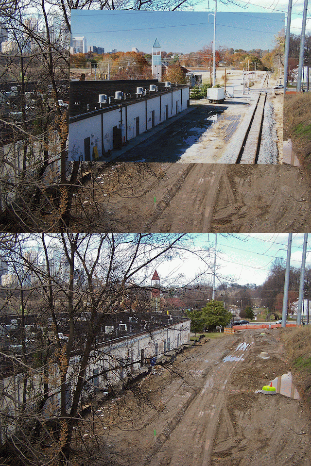
That's right! After a lengthy layoff, the time feels right to begin round three of my photographic journey. I started this blog in 2012 during the early stages of the eastside Beltline construction, comparing its progress to photos I had taken in the 1990s when it was still an active railroad. Now that the trail has been paved, I have once again returned to continue where we left off. I'm walking the Beltline eastside trail from Cabbagetown to I-85 with dozens of stops along the way. Stay tuned...

2025 Update: After spending time on the beltline in spring 2023 and seeing all of the unfinished construction, I decided to wait until the entire northeast trail was paved, which it now is. Now I'm waiting for cooler weather. See you in the fall!

Monday, April 13, 2015

The Bankhead "Bridge To Nowhere" in music videos

The old Bankhead Avenue / Highway "Bridge to Nowhere" near Marietta Street continues to hold an odd fascination for many Atlantans. There is even a Yelp page dedicated to it! In the '80s and '90s it was a popular location for bands wanting to add a little extra industrial grit and urban edge to their music videos and promo photos. I thought it would be fun to post some of them here.

Thanks to Lloyd Bank for pointing out this 1991 video I'd never seen before, "Exclusivity" by Damian Dame. The scene with the bridge starts at about 1:19.


The bridge looks like it was still open to traffic in this video by Michelle Malone and Drag The River. I'm guessing this was 1989 or 1990.


Here is the mighty Hell's Kitchen posing in that desolate wasteland that was once the west side. That handsome man with the smiley-face shirt is my cousin Jay. Hopefully he won't mind me posting this here.


Know of any other videos or vintage band photos featuring the Bridge To Nowhere? By all means, let me know and I'll add them to this collection!

Monday, April 6, 2015

Rio Mall and the Globe of Frogs

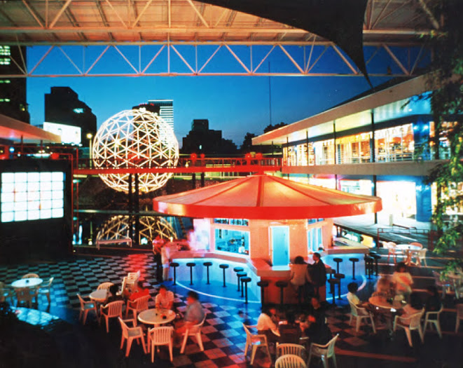
Stunning night view of Rio courtesy of Ackerman Development.
Stunning night view of Rio Shopping Center courtesy of Ackerman Development.

It was a cloudy spring morning and I had just driven 25 miles into town to pick up a bag of Dunkin Donuts original blend ground coffee at the corner of Piedmont and North Avenue. OK, so that's only half true. More accurately, I'd come to contemplate lost eras of golden amphibians and buttermilk (this area was once known as Buttermilk Bottoms). It was a pilgrimage, a bittersweet trip down memory lane through aisles of AA batteries, Pampers, Colgate, and Diet Rite. Here, between shelves of paper towels and drain cleaner, I'd come to reminisce and pay my respects to that bastion of futuristic tropical kitsch, Rio Shopping Center, and its endemic fauna: a static battalion of 300 gilded frogs. With my petty purchases I would try to reconcile the futility of their premature extinction with the basic 21st century convenience of being able to pick up Pop-Rocks, motor oil and prescription drugs in the same place at the same time.


Top photo: Rio Shopping Center on September 12, 1993. Atlanta Journal-Constitution photographic archives.
Bottom photo: April 2, 2015. Rio was demolished in 2000 and replaced by Walgreen's, Publix, and the Savannah Midtown Apartments, seen in the background at top right.


To set the stage and put this rambling story in a personal context we must first travel back to a tired, odd smelling three-bedroom apartment on Buford Highway in early 1988. It was my first apartment. My closest high school friends were also living nearby, attending Georgia Tech and Emory University. As was typical of boys our age, our ears were saturated with the "college music" of the day: REM, Let's Active, The Cure, XTC, and Robyn Hitchcock, whose album Globe Of Frogs was in heavy rotation both on Album88 and my bedroom turntable. The surrealistic songs evoke images of mysterious frogs gathering in formation, alternately mating and migrating, inhabiting a dimly-lit realm of luminous ponds and puzzling spheres.


"And in a globe of frogs, the moth unfurls its moistened wings"
Since the late 1970s, the area along Piedmont Avenue between North Avenue and the Civic Center had been a pastoral green oasis in an otherwise seedy part of town. One could stand on Piedmont and look east across a hilly, nearly half mile expanse of green grass dotted with old oak trees, swaths of kudzu, and mysterious patches of concrete. I often asked what used to be there and why it had been cleared out. "I think they were going to put an expressway through there" was a common reply. (We'll find the real answer in an upcoming post.)

Ackerman & Co. manager Rand Wentworth on the construction site of the Rio Shopping Center, December 17, 1987. From the Atlanta Journal-Constitution Photographic Archives. Special Collections and Archives, Georgia State University Library.
Driving down North Avenue one evening in late 1988 I was shocked to see that the pastoral view had been destroyed and replaced with bulldozed red clay and what looked like a giant blue corrugated metal shed. "Probably another self-storage warehouse. Oh well, that sucks", I remember thinking to myself. 

A few days later I received a call from my friend Christo: 
"Have you seen the globe of frogs?" 
I figured he meant a music video for the Robyn Hitchcock song. 
Me: "No, I don't have cable."
C: "No, it's a real globe of frogs. Piedmont at North Avenue." 
Me: "That blue warehouse?" 
C: "It's a shopping mall. You need to go look around. And take your camera."

This was really intriguing. First of all, I hate shopping malls. For Chris to suggest that I willingly visit one meant that whatever lurked beyond that corrugated blue facade must be pretty amazing. The next day I came home from school, grabbed the camera and headed down to see what all the fuss was about. I was told to enter from the Piedmont side. Walking around the building from the parking lot up to the sidewalk as instructed, I was stunned by what I found.

My first impression of Rio, November 1988.


Rio's surreal landscape was designed by Martha Schwartz, whose website includes additional photos and this amusing and absolutely perfect description:

A squadron of gilded frogs worships a geodesic globe in the courtyard of a specialty shopping center in midtown Atlanta. With architecture designed by Miami–based Arquitectonica International, Inc., Rio Shopping Center boldly asserts itself among the chaos of a cluttered interdiv in an area ripe for revitalization. The globe serves as a beacon for the retail center whose first level of shops opens onto a courtyard ten feet below the street.

Overlapping squares of lawn, paving, stones, and architecture form the basis of the design. The squares are layered with other geometric pieces — lines, circles, spheres, cubes. These elements meet in a mysterious black pool which is striated by lines of fiber optics that glow at night. A floating path, reflected above by an architectural bridge, connects one side of the shopping area to the other. 

The frogs are set in a grid at the base of the 40 foot high globe which is located on a slope connecting the road to the courtyard. Alternating stripes of riprap and grass cover the slope. The grid of frogs continues down the slope and through the pool, all facing the giant sphere as if paying homage. The globe, which also provides support for vines, houses a mist fountain. A square plaza beyond this focal point forms a meeting place which includes a circular bar, a bamboo grove that punctures the roof, and a video installation by artist Darra Birnbaum. 

The video wall at Rio with midtown skyscrapers in the background. Atlanta Journal-Constitution Photographic Archives. Special Collections and Archives, Georgia State University Library.


Here's a detail of the previous photo showing two more demolished Atlanta landmarks: the Jetsons-era C&S tower and the mid-century First National Bank building.

Rio looked like a combination of Logan's Run, Miami Beach, and the set of an '80s MTV video countdown show, which I almost expected to see playing on the giant video wall. Who knows, maybe the place was named after the Duran Duran song. That wouldn't have been surprising. Rio was ridiculous. It was absurd. It was sublime. It was something previously unimaginable in Atlanta: a shopping center with a sense of humor. I imagined a future in which surrealism, irony, and humor would become as integral to architectural design considerations as support beams, insulation, and electrical conduits. The optimism that Rio engendered in my tender 21 year old brain is impossible to overstate. I was convinced Atlanta had entered a new era and the frogs were leading the way. I wasn't alone in my admiration; Business Week gave Rio a "Best Architecture" award, Atlanta Business Chronicle named Rio "Best New Retail Development" and the mall also won the Fulton County Developers Award for best new retail project.

            Up they rise their pretty little heads
            And when she waters them
            They glow and smirk and smile in their beds
            And in a globe of frogs, they're making love and looking on

            
            From "Globe of Frogs" by Robyn Hitchcock


The sea of golden frogs, spring 1989.

During my first visit in late 1988, construction workers were still adding the final touches before the official opening and they were clearly annoyed by the spectators wandering around the property, me included. As I crouched down to get a close-up shot of a golden frog, a beer-bellied worker with a thick southern drawl said "After you get one [a photo] of him, get one of yourself." I guess that was meant as an insult because he and his co-workers laughed and walked away. What did they know? If the universe had any sense of justice, those guys would be installing grids of gold frogs all the way to California.

Rio quickly became a place to take out of town guests. It was enough just to stand on the bridge at sunset and watch the underwater fiber optics change colors. We were easily amused. It also made a fantastic backdrop for our band promo photos. Here's Orange Hat on June 3, 1989.


The view from near the same spot in April 2015 is a little less appealing, and not just for lack of awesome '80s hair. The geodesic sphere was located in the area of the car at far right. The drive through alley is exactly in the center of the location of the former frog pond.


This is a Google Earth "mash-up" showing Walgreens, Publix, and the Savannah Apartments complex sitting on top of a 1993 aerial. The intersection of North and Piedmont is at bottom left with Piedmont running left to right. Rio's geodesic sphere and diagonal bridges can be seen in the location of the current parking lot.


In 1989, I had the privilege of seeing Robyn Hitchcock perform an in-store acoustic set at the Turtles Records on Ponce, which was right next to the Plaza Theater. Afterwards, he signed autographs and I had planned to tell him about Rio's globe of frogs. What a great photo op that would be! There was no need, virtually every single person in line in front of me blurted out, "You have to go see the globe of frogs! Have you seen the globe of frogs? It's just around the corner. I can take you there. Blah, blah, blah..." He seemed completely disinterested and rarely even made eye contact with those in line. After a dozen people had broached the subject, he finally snapped. "Come on, I've got to be in Athens in two hours!" And that was that.

Robyn Hitchcock shrugging off yet another recommendation to visit Rio Shopping Center, spring 1989.
 
By 1990, it occurred to me: When are all the stores going to open? Where are all the customers? Why is this place always deserted? When is the food court going to open? Why is the video wall never working? Is this it? A year after opening, it was obvious things weren't going well. How could the coolest mall in Atlanta turn out to be such a flop? What's wrong with everyone?
A mother and child enjoy the frog pond in an otherwise customer-free mall. The gold frogs were a prized catch for thieves in search of a funky lawn ornament or frat house accessory. At least a half dozen are missing in this June 1990 photo. I'm pretty sure they were solid concrete and must have weighed 80 pounds each. Atlanta Journal-Constitution Photographic Archives. Special Collections and Archives, Georgia State University Library.

I tried to support Rio as much as possible in the early '90s. Our band spent months at the Video Editor editing our "movie" Pork Rinds in the glorious VHS format. We often dined at Heera of India where we were usually the only patrons despite the great food. I bought a Scooby Doo t-shirt and Gumby hat at the funky hat shop downstairs in the corner. Almost weekly, we ate at Lettuce Souprise You overlooking the frog pond. In retrospect, I did more harm than good there; my boss was buddies with the manager of their Briarcliff location and I had a huge stack of free meal passes. They lost money every time I walked in the door.

A lunchtime crowd of 4 people. Lettuce Souprise You was upstairs on the left. I ate countless free meals in those red chairs.


I believe the last time I set foot in Rio was the day this photo of Sinead the mannequin was taken, December 10, 1995. (This was part of an abandoned photographic project tentatively titled "Sinead's Atlanta: A Mannequin's Guide To The Olympic City".) Anyway, I stopped going after that. It had become depressing, like watching a loved one wither away from illness. The paint was peeling, the underwater fiber optics had stopped working, the video wall was covered in bird droppings, the frog pond was full of leaves and many of the frogs had long since been stolen, presumably carted off to enliven dorm rooms and backyard gardens.
 
"I feel like Farrah Fawcett in Logan's Run!"


Rio Mall appears as the backdrop for a distracted lab scientist in this video by Atlanta psych-pop band Orange Hat.


It was no surprise when Rio was bulldozed in 2000. It was also no surprise to see it replaced with a Publix, Walgreens, and a monstrous apartment complex, places that represent the polar opposite of Rio: practical, profitable and completely devoid of any sense of individuality or uniqueness. 


          And when the night comes down
          The houses close their doors and dream of her
          Their shuttered eyes are closed
          Inside their curtains wrap around her form
          And in a globe of frogs, we're linking tongues and moving on


          From "Globe of Frogs" by Robyn Hitchcock 


Yes, I still miss the frogs but I actually did need the coffee this morning.


In an upcoming post, we'll see what was here before Rio.


Wednesday, August 1, 2012

What Transit In Atlanta Should Look Like

This map was produced by Citizens for Progressive Transit in 2006 and illustrates what transit in Atlanta should look like. Click HERE for the hi-res version.


Ironically, the routes extending to the edges of the map in all directions, listed here as Commuter Rail, were operated multiple times daily by the major railroads 50+ years ago. I live near Conyers on the east side of Atlanta and the restored ninteenth century rail depot is still adorned with a sign showing mileage to Atlanta and Augusta. Once upon a time you could have boarded a train here and arrived at Atlanta's Union or Terminal stations in 45 minutes. From there you could have connected to trains bound for anywhere in the country. It all sounds whimsically futuristic, doesn't it?


Conyers depot: from here to anywhere in the U.S. Hard to imagine.


Thursday, May 17, 2012

Virginia Avenue over the BeltLine, facing south

This was the view facing south from the Virginia Avenue bridge over the Norfolk Southern railroad on November 26, 1995. The old Sears building, aka City Hall East, dominates the horizon.


17 years later, the railroad is long gone and the Atlanta BeltLine construction is underway. As with most of my BeltLine photos, I plan to take a third photo after construction is complete. For a view from the other side of the bridge, click HERE.


This aerial photo from 1949 shows the extent of the industrial infrastructure that once existed along the railroad at Virginia Avenue and Monroe Drive. (Monroe runs north to south on the left side of this photo). The white arrow shows the location and the orientation of the above photos.


Google map of this location:


View Larger Map

Wednesday, May 16, 2012

The Beltline at Virginia Avenue 1995 / 2012

These two photos were taken from the Virginia Avenue bridge over the Norfolk Southern "Decatur Belt" which is now being redeveloped as the Atlanta BeltLine. The top photo was taken on a gorgeous autumn afternoon, November 26, 1995. The second one was taken on a slightly dreary winter morning in February 2012. The railroad crossing seen here is (or was) at Monroe Drive. Piedmont Park is just beyond that and the skyline of midtown is in the distance. I'll come back to get a third photo once the BeltLine is complete.


I've been told many times that animated gifs annoy people, so at the risk of annoying you, here are the same two photos superimposed and animated.


This is a combination of two photos of "unidentified" locations from the Atlanta History Center that were taken in February 1971 just a few yards from where I took the above photos. (Note to the AHC: for a small fee I'd be happy to identify the locations of your photos!) This is looking down Kanuga St. towards Monroe from Virginia Ave. The railroad ran parallel to Kanuga and is to the left of the road in this shot. As you can see, the midtown skyline consisted of a single skyscraper in 1971.


Google map of this location:


View Larger Map

Monday, March 19, 2012

Airline Street 1997 / 2012

More shots from the southern end of the Decatur Belt rail line. This is the view facing north on Airline St. at the Norfolk Southern railroad crossing. Photo taken November 1997.


Nearly 15 years later the railroad and metal company are gone and Atlanta's now ubiquitous condos have crept into the shot. February 2012.


Facing west from the same spot on Airline Street.
November 1997 / February 2012.


And, still from the same spot, the view facing SW toward Cabbagetown.


Related posts:
The Beltline at Edgewood


View Larger Map

Wednesday, March 14, 2012

Decatur Street and the Decatur Belt

Driving east down Decatur Street / DeKalb Avenue near Airline and Krog Streets, November 1997:


The same view in February 2012:


This was the southern end of the old Norfolk Southern Railroad Decatur Belt. In these first two photos the tracks dead end into an embankment on the right. For more than a century, they connected to what is now the CSX mainline at Cabbagetown. This connection was severed in the mid 1980s when the old Hulsey rail yard was replaced with a modern piggyback facility, requiring the realignment and regrading of the CSX mainline. I was (and still am) amazed the old railroad signals are still in place nearly three decades since the last train crossed here.

The view driving west: (I'm a safe driver. No, really.)

Top: November 1997   Bottom: February 2012

Here's a Google Maps view of the former railroad junction which was buried when the CSX tracks were realigned in the 1980s.


The bird's eye view from 1892. Part of the Fulton Bag and Cotton mill in Cabbagetown can be seen at bottom right.


The bird's eye view roughly 120 years later, courtesy of Bing maps:


Tuesday, March 13, 2012

Decatur Belt Map

I'll be posting more now & then photos from along the former Norfolk Southern Decatur Belt rail line in the coming weeks and thought it would be handy to have a map as a reference for readers. This stretch of former railroad is considered the prime segment in the ambitious Atlanta BeltLine project and major changes are already underway. It will be interesting to see what happens in the coming decades, which means I'll probably be returning and taking these now & then photos until I'm too old and senile to get around.

This map comes from the Georgia DOT via Fresh Loaf. Larger version HERE.


Wednesday, March 7, 2012

Goody's on Ponce

Top: December 10, 1995  Bottom: March 1, 2012
OK, the obvious question: "What's up with that mannequin?"

Inspired by the book The Red Couch, in which a red velvet sofa is taken across the USA and photographed in various odd locations, I decided it would be a brilliant idea to take our band's mannequin Sinead on a similar tour of Atlanta landmarks. Somehow I convinced a few friends to help out and we set sail on this beautiful sunny afternoon. Unfortunately, it was about 38 degrees and really windy, and after an hour of frozen numbness, we gave it up. Traumatized by the experience, and feeling kinda silly walking around town with a mannequin on my head, I never completed my own twisted little coffee table book. Too bad, because now it seems like it would've been pretty cool.

Anyway, back to Goody's... The building has been abandoned for years. Who would have thought that film would die such a quick death and that Kodak would be on its deathbed only a decade after digital cameras became commonplace? I expect more condos as soon as the economy improves.

My friend "The Mover", who assisted me on the ill-fated mannequin expedition, also documented this stretch of road in 1995 with a series called The Ponce de Leon Panorama Project. Here is his shot of Goody's.

Ponce Panorama #17

To see The Mover's massive 30-shot panoramic montage of mid-1990s Ponce, just click the photo below. Be sure to check to peruse his photos on flickr. There are hundreds of great pictures from around Atlanta.

Ponce de Leon Avenue Panorama Project 1995


Sunday, February 19, 2012

The Beltline at Edgewood pt 2

Here are a few more photos taken from the Edgewood Avenue bridge over what will eventually become the BeltLine trail. These are facing north towards Irwin Avenue. The view facing south can be seen in this earlier post.

This section of the Norfolk Southern "Decatur Belt" had been abandoned only a few months before this first photo was taken in November 1995. Kudzu had just begun to creep over the rails. In the photo at right, taken February 2012, the rails have been pulled up, the homeless camp cleared out, and the trees have doubled (or quadrupled) in size.


This field was the site of several warehouses of the abandoned South East Atlantic Cotton Compress complex. The warehouses were destroyed in a spectacular fire on July 3, 1991, reportedly started by fireworks. I could see the fire from Doraville! The remaining buildings are now part of the Studioplex lofts and much of the site is now a parking lot. The building at far left is not part of the complex and is still abandoned. Top photo: November 1995. Bottom: February 2012.


Despite the dramatic changes all around it, this view is nearly unchanged in 17 years. Left: November 1995. Right: February 2012.


Here's a 1972 aerial view of the massive triangular warehouse complex that burned down in 1991. The Edgewood Avenue bridge is at the bottom of the photo.


In the 1892 Birdseye View of Atlanta, this was the site of a railroad maintenance facility including a roundhouse, turntable, coaling tower and associated buildings. Inman Park is at far right and a trolley line is shown on Edgewood (at bottom).


Google map of this spot:


View Larger Map

Monday, February 6, 2012

North Highland Avenue at the BeltLine

Another excursion into the gentrified Twilight Zone that is now Atlanta! Of the many places I have revisited in the last month, few have changed as radically as the stretch of North Highland Avenue between Inman Park and the Old Fourth Ward. What had been an industrial ghost town during the early 2000s has been transformed into a bustling mini-city seemingly overnight. Upon my return, I felt like Charlton Heston in Planet Of The Apes, but instead of being surrounded by talking apes on horseback I found myself surrounded by hordes of well dressed 30 year-olds and very expensive cars. The smell of coffee and creole food wafted from the direction of what had previously looked like a post-apocalyptic metal yard. Joggers in fluorescent neoprene suits jogged over the bridge that had served as shelter for a homeless encampment. We're not in Kansas anymore, Toto.

Here's a fantastic aerial photo from around 2001, "borrowed" from the website of Surber, Barber, Choate & Hertlein Architects, the firm that redeveloped much of this stretch of North Highland. The massive building at center was the Mead Paper manufacturing plant. To the right of that, across the street, was the General Pipe and Foundry complex that occupied the site for nearly a century.


Instant city: looking east towards Inman Park. The last time I drove through here, probably in 2001, this was an industrial wasteland of giant metal sheds, abandoned scrap yards and sprawling manufacturing plants. I now find myself in a strange new world. I wholeheartedly support the concepts of new urbanism but can't help feeling these buildings look like college dormitories.


This was the entrance to the abandoned Grinnell piping and design company, located at 200 N. Highland, as seen in November 1995. One thing I love about many old industrial and commercial buildings is the amount of detail and ornamentation that went into the design. The idea of spending extra time and money on such details simply because they are aesthetically pleasing seems almost unthinkable today.


Thankfully, the front facade was saved when the property was redeveloped as loft apartments and it looks completely surreal standing below sliding glass doors and balconies.


Here is the view looking north from the N. Highland bridge over the Norfolk Southern railroad, which was still in use when I took the first photo in November 1995. In the second photo, taken in February 2012, the old steel complex has been replaced by the cleverly named Steel Lofts. The construction of the BeltLine is well underway.


On the other side of the bridge, this is the view facing south towards the Old Fourth Ward water tower. The photo at left was taken November 26, 1995 and shows the Mead paper manufacturing plant. The photo at right was taken February 2, 2012.


Here's the same 1995 photo superimposed over a wider angle of the current view. I always love this effect of the past superimposed on the present.


Another shot from the same spot on the N. Highland Avenue bridge in 1995 facing south towards Cabbagetown and the Fulton Bag and Cotton mill.

Today the view is blocked by these apartments.

The stunning transformation of this area is possibly best summed up by comparing these two business descriptions from former and current occupants of the N. Highland steel site:

Then: GRINNELL Products delivers a complete suite of grooved piping solutions for a full range of mechanical, HVAC, commercial, mining, institutional, and industrial applications. Available products offer contractors, engineers, and distributors faster, more cost-effective tools for joining pipe over traditional welding methods.

Now: BROWBAR is the ultimate luxurious destination in Atlanta for brow grooming, full body waxing, organic facials, lashes, tinting & makeup & toxic free manicures by Zoya Nails! Whether it's creating the perfect brow shape for your face, removing all of your unwanted hair or rejuvenating your face, our professional aestheticians can help you achieve all of your goals.


View Larger Map

As always, thanks for joining me on these timed-warped "Sunday drives". Much more to come...