Monday, January 30, 2012

Driving in Atlanta 1987 & 1990

I often regret that I didn't stick a video camera on my dashboard and drive around Atlanta back in the 80s and early 90s. Thankfully, a few others did exactly that and have posted the videos on Youtube.

This first one is from Youtube user reillync and was shot in August 1987. It's interesting to see the construction mess during the widening of the downtown connector.


dirtypairxx posted this one from 1990 or 1991. It begins in southwest Atlanta and then heads north on Peachtree. You can see what the Margaret Mitchell House really looked like before the restoration.

Sunday, January 29, 2012

The Beltline at Edgewood

This is the view from Edgewood Avenue facing south towards Cabbagetown. The left photo was taken November 2, 1997 and the photo at right was taken January 25, 2012.


This is the southern end of the old Southern Railway "Decatur Belt" which was abandoned around 1995 - 1996. It is now considered one of the prime sections of the ambitious Atlanta Beltline project which will include a network of trails, parks, and transit. Even before the Beltline idea was officially hatched, it seemed likely that the old rail line would be converted into bike trails or new roads. Either way, it was obvious that big changes were on the way so I followed the entire line from Cabbagetown to I-85 near Ansley Park on a beautiful November afternoon in 1997 and took a few dozen photos along the way. Many more to come...


View Larger Map

Saturday, January 28, 2012

Before Historic Fourth Ward Park : Kelly's Seed & Feed Theatre

Top photo: January 1989 
Bottom photo: January 2012

In the 1980s I was intrigued by this forlorn industrial building with the Hee-Haw feed store paint job and psychedelic lettering. It seemed destined for demolition so I took this photo on a dreary January day in 1989. Amazingly, the building stood for almost another 20 years until it was demolished to make way for the new Historic Fourth Ward Park. The site of the park, adjacent to the old Southern Railway "Decatur Belt", had primarily served as an industrial area since the late 1800s. Most of the industries had moved out by the 1970s and a few of the properties were converted into restaurants, night clubs, and live theaters. This particular building was located on North Angier Ave. between Dallas and Morgan Streets just south of the Sears Building and Excelsior Mill / Masquerade. It was once a bottling plant for May's Beverages and in the late 1970's became the home of Kelly's Seed & Feed Theatre, which presented live stage shows. The theatre closed in the mid 1980s and, judging from the sign, subsequently saw use as a body shop. It was abandoned when I took the photo in 1989.

Here are a couple of photos of the Seed & Feed Theatre from the Georgia State University Library Digital Collections . The title of this first one reads "Steve Lindsley, Tom Cullen, and John Wittemore on the roof of Kelly's Seed & Feed Theatre, Atlanta, Georgia, 1979?"


The caption for this one is "Three Magi, from "The Play of Herod", Kelly's Seed & Feed Theatre, Atlanta, November 1983."


This is the view facing north on N. Angiers on beautiful autumn day in 1997. The May's Beverages sign was still clearly visible decades after the bottling plant closed. The same view in January 2012: the industrial area has been replaced by the Historic Fourth Ward Park. Ironically, when I returned on a strangely warm 70° January day, the place was more lifeless and deserted than ever.


I found this interesting history about May's Beverages over at Bottlebooks.com: May's Beverages-Atlanta May's Bottling Company, 544 North Angier Avenue N. E. Atlanta, was a division of American Associated Companies Incorporated. May's originally was a bottler of Mil-Kay, Bireley's & Topp Cola in Atlanta, and was in business from around 1932 to 1972. In 1962/3 decision was made to change name to May's Beverages-Atlanta, May's Bottling Company, at which time they switched to primary bottling of "May's chocolate flavored drink", the bottling division was discontinued in 1972. They had a United States Patent for the unique way of pasteurization they used in the bottling of their chocolate drink. 

Google Map of this spot:


View Larger Map

Thursday, January 26, 2012

Old Fourth Ward water tower

Few areas of Atlanta have been transformed by gentrification as dramatically and quickly as the Old Fourth Ward, east of downtown. During the 1990s, the area was dominated by old run-down houses, trash strewn vacant lots and abandoned warehouses. When I returned yesterday, I was completely disoriented by the changes that have taken place in the last 15 years. Gone are the burned out buildings, vagrants, and empty streets. They've been replaced by restored homes, infill houses, unimaginable numbers of new condos and an exponential increase in traffic. While these developments have breathed new life into the area, they've also created a sense of claustrophobia. The wide open views of the old concrete water tower and the nearby Cabbagetown mill, two major landmarks that could once be seen from almost any street in the area, have largely been obscured by the new developments. For me, the result is a tinge of Twilight Zone vertigo that comes from being in a familiar place, remembering how it used to be, and trying to reconcile that with what your eyes now see before them. For a native who grew up in Atlanta before the Olympics, these views are nothing short of surreal.

Here's the Old Fourth Ward water tower as seen from Gaspero St. The top photo was taken January 10, 1990 and the bottom was January 25, 2012.

The water tower was built in 1906 as part of the South East Atlantic Cotton Compress Warehouses (now Studioplex lofts). The complex is shown in this 1919 birdseye view of Atlanta.

I've had several requests for links to Google Maps on previous posts, so... here ya go!


View Larger Map

Monday, January 23, 2012

Peters Street Depot

One of the inspirations for driving around Atlanta and photographing 19th century industrial buildings was found at the Brookhaven library way back in 1987, a fantastic book with the unglamorous title "Atlanta Historic Resources Workbook". Published by the Atlanta Urban Design Commission in September 1981, the book painstakingly details the history and significance of hundreds of structures and historic districts around town, everything from the Fox Theatre and the Flatiron Building to houses and old bottling plants. I managed to find a well worn ex-library copy on Alibris a few years ago. It's a fascinating time capsule and profiles many historic structures that have since been demolished.

One of the more obscure entries in the book was this nondescript freight depot in the Castleberry Hill area.


The old depot is the white brick building on the left of this photo I took from a parking lot off of Spring Street on January 10, 1990. A fire destroyed the structure in 1992.

Something I never anticipated when to returning to sites I had photographed two decades earlier is the astonishing proliferation of chain link fences. There are now fences on bridges, fences underneath bridges, fences blocking access to bridges, fences around parking lots, fences around vacant lots, fences along the railroad, fences around buildings, fences across driveways, fences across roads. Fences, fences everywhere! One such fence kept me from recreating the same perspective of the above photo, but this is pretty close. January 5, 2012.

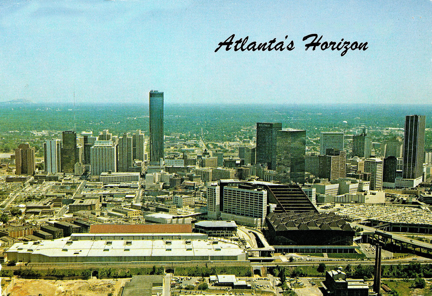
A much better view of the old depot can be found on this 1989 postcard of the former Atlanta & West Point engine 290. Locomotive #290 was built in 1926 for the Atlanta & West Point and operated with the New Georgia Railroad during the late 1980s and early '90s. It also appeared in the movie Fried Green Tomatoes (...not to mention Decompositions) Anyway, #290 is now on display at the Southeastern Railway Museum in Duluth, GA.

Date of top photo: September 12, 1989
Bottom photo: January 5, 2012


An interesting comparison of bird's eye views from 1892, 1919, and 2010. What is striking about the first view is how self contained this area appeared to be in 1892. Before the advent of the automobile, houses, businesses, and industries were, by necessity, within walking distance of each other. The railroad depot was the focal point of the neighborhood. In the modern view, those relationships are completely lost.


Thursday, January 19, 2012

The Giant Layer Cake

Atlanta has a long history of constructing viaducts, buildings, plazas, parks and parking decks above rail lines, creating vast "underground" areas that are largely unknown to the general public. One of the most impressive examples of this concrete and steel "layer cake" is the area surrounding the Magnolia Street underpass, now hidden far below the plaza between Philips Arena, the Georgia World Congress Center and the Georgia Dome. Greg de Torony sent this terrific photo. The original 19th century railroad embankment (circa 1870s) is almost completely obscured although it is still one the busiest rail lines in the city. The green bridge just beyond that was constructed in the 1970s. The remaining structures have been built since the early 1990s.


Here's what it looked like 35 years earlier. This postcard view of the Atlanta skyline in 1976 is one of thousands of great images found on Greg Germani's wonderful Atlanta Time Machine. The Magnolia Street underpass can be seen between the World Congress Center and the Omni, just to the left of the factory in the foreground.


A closer view... This shows the newly constructed second underpass to the left of the original one.


This 1967 view shows part of the extensive rail yards that filled the area before the closing of the nearby Union and Terminal passenger stations.

Tuesday, January 17, 2012

The ABC

Local railroad history expert and Unseen Underground Walking Tour mastermind Jeff Morrison sent the following information about the subject of my last few posts, the railroad line that occupied the site of the Georgia Dome. Thanks Jeff!

"Here is an excerpt from the research we did for the Beltline. I seem to recall that the yard in question was called the Haynes St yard.
" - Jeff

Overview
Known as the “Route of the Dixieland”, the Atlanta Birmingham & Coast spanned from Birmingham, Alabama to Brunswick, Georgia, with a branch line from Manchester, Georgia to Atlanta. The AB&C was the last railroad line built into Atlanta, and its late arrival left few options for an approach and yard location. Coming north from Fairburn, the line entered Atlanta from the less populated west side, with a cramped yard at Bellwood. From there, an elevated line crossed the existing street grid to a freight station just west of the “railroad gulch”, at a site now occupied by the Georgia Dome. In 1959 the Atlantic Coast Line moved yard operations from Bellwood to the L&N’s recently expanded Tilford Yard.


Ownership History
In 1906, the AB&A consolidated itself with the Atlantic and Birmingham Railway and began operating under the Atlanta, Birmingham and Atlantic Railroad name. Continuing financial problems resulted in a reorganization in 1915 (with a new name, the Atlanta, Birmingham & Atlantic Railway) and foreclosure in 1922. The Atlanta, Birmingham & Atlantic Railway was reorganized in 1926 and renamed the Atlanta, Birmingham & Coast Railroad. It was controlled by the Atlantic Coast Line which had acquired a majority of its stock. The railroad was nicknamed "the ABC." In 1946, Atlantic Coast Line purchased the company entirely and absorbed it into its own operations as the Atlantic Coast Line western division.

Monday, January 16, 2012

Before the GA Dome and World Congress Center expansion (part 3)

This is the Foundry Street underpass as seen from Haynes Street on January 10, 1990. The World Congress Center and Mangum Street are just beyond it. Later that year, the embankment and old industrial buildings surrounding it were demolished for the construction of the Georgia Dome. This exact spot is now several stories below a plaza that runs between the Dome and the expanded World Congress Center convention hall.


I often wondered what this area looked like before it was engulfed by the Congress Center, The Omni, the Georgia Dome and, later, Philips Arena. Thankfully, the Atlanta History Center has a series of photos taken from the top of this railroad embankment by Herbert H. Lee in August 1969.

The corner of Magnolia and Mangum is at bottom right and the Magnolia St. viaduct is in the distance. That particular underpass still exists but is hidden far below the raised street level and parking decks just north of Philips Arena.


The area west of downtown has long been one the most impoverished areas in the state of Georgia. The following two photos depict the nearly third world conditions of the neighborhood that was cleared to build the World Congress Center. This is Mangum St. as seen from the railroad embankment.


When was this massive railroad embankment built? The Sanborn Insurance map from 1911 shows that the AB&A Railroad, short for Atlanta, Birmingham & Atlantic, owned the tracks. According to RailGA.com, the company was organized in 1905 to build a line from Warm Springs, GA to Atlanta, although the completion date isn't mentioned.

A quick search through the Atlanta Journal Constitution archives found this headline and synopsis from August 25, 1906:
1,500 HOMES WILL BE RAZED ON WEST SIDE. OCCUPANTS NOTIFIED TO MOVE OUT AT ONCE - Great Developments at an Early Date Expected on the Property Purchased by Gate City Terminal Company for Atkinson Line. Fifteen hundred homes will be razed on the west side to make way for the terminals and tracks of the Atlanta, Birmingham and Atlantic railroad. 

By early April 1908, a temporary wood terminal had been constructed at the corner of Hunter, Haynes and Mangum in anticipation of the first freight trains later that month. 


The April 12, 1908 edition of the Atlanta Constitution reported that freight service was scheduled to begin on Tuesday, April 14th. The first passenger train traveled the line on Friday, May 8th.

Considering the amount of dirt that had to be moved, the embankment and elevated railyard were an impressive feat.


The Library of Congress has posted several "Bird's Eye View of Atlanta" maps from the late 1800s through the early 1900s online and they are absolutely fascinating if you're even the least bit interested in local history. Here is a view of the area just west of downtown in 1892. Davis Street is better known these days as Northside Drive. The gas tanks seen at the bottom right are now the site of Philips Arena.


This map from 1919 shows the AB&A tracks and rail yards to the left while the railroad "gulch" and Terminal Station platforms can be seen at far right.


Finally, here is a 2012 view of the same area courtesy of Google Earth.

Saturday, January 14, 2012

Before The Georgia Dome part 2: Sharky's Machine

Today's post follows a very cool unplanned detour. The previous entry about the industrial area that once occupied the site of the World Congress Center and the Georgia Dome prompted reader dingo5150 to write that the intro to the 1980 Burt Reynolds movie Sharky's Machine was filmed there. A quick search on Youtube and there it was. It begins with a spectacular aerial scene - one long shot that begins high above the Westin Peachtree Plaza at sunset and slowly works its way down to Burt Reynolds walking along the railroad tracks west of town. It's like a real-life version of a Google Earth zoom. Here are some screenshots...

High above Peachtree Street in 1980, facing northwest. The area to the left of the frame is now the site of Centennial Park, The Georgia Aquarium and the World Of Coke.


Heading west at sunset. The Omni International (now the CNN Center) is at center, the World Congress Center is at right, and the Tabernacle is at the bottom of the shot.


The intersection of Techwood and Marietta Street is at bottom left.


This is the former industrial area that is now the site of the Georgia Dome and the expanded World Congress Center. The Magnolia Street tunnel that crossed beneath the elevated rail yard is in the foreground.


Here's a shot of Burt walking along the tracks with the World Congress Center immediately behind him.


And finally... a link to the video. Beware, you might just have "Street Life" stuck in your head for the next 2 days.

Thursday, January 12, 2012

Before the Georgia Dome & the World Congress Center expansion (part 1)

January 10, 1990 I spent a marathon afternoon photographing old industrial areas of Atlanta, from Atlantic Steel, Howell Junction, Cabbagetown, Fourth Ward and Castleberry Hill all the way down to East Point and Hapeville. The most eerie and desolate area I visited that day was between the World Congress Center and Northside Drive in Vine City. The former industrial and impoverished residential area was being cleared to make way for the Georgia Dome and its accompanying endless sea of parking spaces. It was a surreal landscape. Street signs, power lines and trees were still in place but every single home had been demolished and cleared. Dominating the area was a massive 19th century railroad embankment that once carried trains travelling between Birmingham and downtown Atlanta. Within a few months it was gone too. In the early 2000s the World Congress Center undertook a major expansion that filled in the entire seen here.


The photo above shows the view facing north on Haynes at the intersection with Thurmond. I had heard tales of carjackings around here and had noticed several sketchy characters in the vacant buildings and under the bridges keeping a close eye on me, so I took these photos while the car was moving. My paranoia was compounded by the black car blocking the road just beyond the bridge in this picture. I managed to take only two photos before moving on.

Here's a Sanborn insurance map from 1911 that shows this intersection and the railroad bridges. Notice the cluster of buildings on the corner of Thurmond. They were all crammed into the space between the telephone pole and bridge on the left side of the above photo!


Since this area is now under the roof of the World Congress Center, a contemporary photo is impossible (unless someone out there can give me a security clearance and a GPS!) I'll admit I had to look at a couple of aerial photos to refresh my memory and figure out the exact location. I saved those aerial photos and placed an arrow on them to mark the spot. The first view is from 1988 and the World Congress Center is the huge building to the right. Northside Drive is on the left side of the photos.


This is the exact same view in 2007. The Georgia Dome is at the bottom of the frame.


Monday, January 9, 2012

Old Bankhead Avenue bridge 1992 / 2012

The old Bankhead Avenue bridge, which crosses the railroad near Marietta Street, was built in 1912 and was one of the main western routes out of Atlanta before I-20 was built. The top photo is actually a frame from a Super8 movie film I shot there in early 1992. Even though the bridge had already been closed, it appeared to be in relatively good condition. A lot has changed since my visit in '92. The ramp from Marietta Street has since been demolished and the area is now a parking lot while Bankhead Highway has been renamed Donald Lee Hollowell Parkway. No one is fooled. Everyone still calls it Bankhead Highway.


Here's another screenshot from the same grainy 1992 Super8 film showing the dedication plaque which is obviously missing in the above photo.


Another screenshot of the old Bankhead Highway ramp from Marietta Street.


The bridge can be seen in the background of this June 2, 1954 photograph of the intersection of Boss and Marietta St.

Sunday, January 8, 2012

Terminal Station 1968 / 2012

My last post was about Atlanta's Terminal Station and since I was taking pictures in this area anyway, I decided to also recreate some other photographers' shots while I was there. This top photo was taken by Martin O'Toole on October 20, 1968 and shows a southbound train with Terminal Station in the background. Also notable is the circular C&S bank building in the distance at top left.


The same perspective from the Peters St. bridge on January 5, 2012 shows a drastically different scene. The Richard B. Russell Federal Building stands on the site of the old station and the skyline has completely changed. The only obvious holdovers from the earlier scene are the now closed Nelson St. bridge, the tan brick interlocking tower (at far left) and the triangular railroad platform at the center of the photo.

Saturday, January 7, 2012

Remnants of Terminal Station

In January 1990 I took this photo of what remained of Atlanta's once spectacular Terminal Station which was demolished in 1972: the interlocking tower (basically a control tower for the station) , the adjacent storage shed, and the triangular platform to the right. The actual station was located just beyond the bridge seen here, now the site of the Richard Russell federal building. The pullman cars in the photo were being used by the New Georgia Railroad tourist trains that ran from Underground Atlanta to Stone Mountain during the late '80s and early '90s.


The 1906(!!!)-vintage Nelson Street bridge, my vantage point in the above photo, is crumbling and has been fenced off. There's the spot from where I took the original photo. I can almost see my 21 year old self standing out there.


Incredibly, the old tower and the triangular platform are both still there. Terminal Station, which was adorned in the same tan brick and red tile roof seen here, opened in 1905 and I presume that this tower was built at the same time.


Did I ever mention that the "photostitch" function is one of my favorite things in the world? The construction project in the background is the new Mitchell Street bridge which replaces the previous one built in 1924.


Here's a view of Terminal Station from the 1930s, the tower and Nelson Street bridge are at far left.


A detail of the same scene.


The statue at the bottom of this photo will be the subject of a later post.

Friday, January 6, 2012

Castleberry Hill 1989 / 2012

This is an old factory building in the Castleberry Hill area of Atlanta as seen from the Peters St. bridge. Top photo was taken in January 1989 and the bottom one was taken January 2012. This former factory was built in 1914 and has been converted to lofts. Not a whole lot has changed between these two shots other than the size of the trees. Off in the distance on the right side, the old Omni Coliseum has been replaced by Philips Arena.


January 5, 2012: The kids had returned to school from Christmas break, my wife was at work and the weather was beautiful. Alone again. Just like the old days. I looked out the window and, for the first time in over 16 years, decided it would be fun to grab my camera, drive downtown and just wander around like I used to do when I was 20. I grabbed a few old photos and set out to retrace the steps of that long haired kid in the 1966 MG.

So I ended up here in Castleberry Hill, an old industrial neighborhood that looks much like it did when I was a train obsessed kid in the 1970s. We used to drive through here on the way to the skating rink at the Omni every weekend or on the way to one of mom's marathon shopping trips to the downtown Rich's department store that once stood a few blocks away. For the most part, this area of Atlanta still looks pretty cool, with the slightly unsettling vibe of an industrial wasteland even though most of the old buildings are now lofts or galleries.

I took the top photo from the Peters St. bridge in January 1989. As I stood in the exact same spot 23 years later, my digital shutter clicks were accompanied by the sounds of a homeless guy playing flute on the opposite side of the bridge. Surreal.

The next photo shows a different view of the same scene taken in 1935 from the Southern Railway building (which is also still standing). This came from the Southern Railway Historical Association.


This 1961 aerial photo of downtown Atlanta is from the Atlanta History Center. These buildings can be seen at far left.


Thursday, January 5, 2012

Atlantic Steel / Atlantic Station

You may (or may not) know that the area now known as Atlantic Station was previously the site of the massive Atlantic Steel mill complex. The steel mill operated from 1901 to 1998 and was demolished in 1999 to make way for the Atlantic Station development. A great article about the old mill can be found HERE.


These were taken from the end of 18th St. on the opposite side of the downtown connector (right behind the Center for Puppetry Arts). This first one was taken in November 1994 with one of those cool little disposable cardboard panoramic cameras. I used to love those things.


The second view was taken a little over 17 years later in January 2012. The mill and rail yards are long gone, the expressway was widened yet again and the little landscape twigs have grown into real trees. I could have avoided having the fence in the shot but that was part of the charm of the original photo.