Wednesday, August 1, 2012

What Transit In Atlanta Should Look Like

This map was produced by Citizens for Progressive Transit in 2006 and illustrates what transit in Atlanta should look like. Click HERE for the hi-res version.


Ironically, the routes extending to the edges of the map in all directions, listed here as Commuter Rail, were operated multiple times daily by the major railroads 50+ years ago. I live near Conyers on the east side of Atlanta and the restored ninteenth century rail depot is still adorned with a sign showing mileage to Atlanta and Augusta. Once upon a time you could have boarded a train here and arrived at Atlanta's Union or Terminal stations in 45 minutes. From there you could have connected to trains bound for anywhere in the country. It all sounds whimsically futuristic, doesn't it?


Conyers depot: from here to anywhere in the U.S. Hard to imagine.


TSPLOST rejected


Friday, May 18, 2012

East of the ATL: Then and Now

I noticed my photo comparisons of the site of the old Lithonia, GA railroad depot have been making the rounds on several blogs and thought I'd point readers to the entire set of photographs. Entitled Now and Then: East of Atlanta, the set features recreations of vintage photos taken in Decatur, Stone Mountain, Lithonia and Conyers, GA. Some of the original shots are nearly a century old! If you enjoy this blog and are a fan of the Atlanta Time Machine, you'll probably dig these too.


Thursday, May 17, 2012

Virginia Avenue over the BeltLine, facing south

This was the view facing south from the Virginia Avenue bridge over the Norfolk Southern railroad on November 26, 1995. The old Sears building, aka City Hall East, dominates the horizon.


17 years later, the railroad is long gone and the Atlanta BeltLine construction is underway. As with most of my BeltLine photos, I plan to take a third photo after construction is complete. For a view from the other side of the bridge, click HERE.


This aerial photo from 1949 shows the extent of the industrial infrastructure that once existed along the railroad at Virginia Avenue and Monroe Drive. (Monroe runs north to south on the left side of this photo). The white arrow shows the location and the orientation of the above photos.


Google map of this location:


View Larger Map

Wednesday, May 16, 2012

Out There Atlanta

I'm the guest on this week's episode of Out There Atlanta, a weekly podcast covering food, arts, events, and people around town. I joined host Lilly Lampe at the Krispy Kreme on Ponce and, fueled by caffiene and sugar, rambled a mile a minute about my photography project, growing up in Atlanta, the virtues of Super8 film and the story of Sinead the Mannequin. Lilly even plays a song I wrote at age 15. All of this and more can be yours by clicking HERE


The Beltline at Virginia Avenue 1995 / 2012

These two photos were taken from the Virginia Avenue bridge over the Norfolk Southern "Decatur Belt" which is now being redeveloped as the Atlanta BeltLine. The top photo was taken on a gorgeous autumn afternoon, November 26, 1995. The second one was taken on a slightly dreary winter morning in February 2012. The railroad crossing seen here is (or was) at Monroe Drive. Piedmont Park is just beyond that and the skyline of midtown is in the distance. I'll come back to get a third photo once the BeltLine is complete.


I've been told many times that animated gifs annoy people, so at the risk of annoying you, here are the same two photos superimposed and animated.


This is a combination of two photos of "unidentified" locations from the Atlanta History Center that were taken in February 1971 just a few yards from where I took the above photos. (Note to the AHC: for a small fee I'd be happy to identify the locations of your photos!) This is looking down Kanuga St. towards Monroe from Virginia Ave. The railroad ran parallel to Kanuga and is to the left of the road in this shot. As you can see, the midtown skyline consisted of a single skyscraper in 1971.


Google map of this location:


View Larger Map

Wednesday, March 28, 2012

Mapping Atlanta: The 2010 U.S. Census

THIS is absolutely fascinating! Gold represents population loss between 2000 and 2010 while blue represents population gains over the same period. Click the illustration to see the NY Times interactive map. Zoom in on any particular neighborhood to see the census details.


Monday, March 19, 2012

Airline Street 1997 / 2012

More shots from the southern end of the Decatur Belt rail line. This is the view facing north on Airline St. at the Norfolk Southern railroad crossing. Photo taken November 1997.


Nearly 15 years later the railroad and metal company are gone and Atlanta's now ubiqiutous condos have crept into the shot. February 2012.


Facing west from the same spot on Airline Street.
November 1997 / February 2012.


And, still from the same spot, the view facing SW toward Cabbagetown.


Related posts:
The Beltline at Edgewood


View Larger Map

Wednesday, March 14, 2012

Decatur Street and the Decatur Belt

Driving east down Decatur Street / DeKalb Avenue near Airline and Krog Streets, November 1997:


The same view in February 2012:


This was the southern end of the old Norfolk Southern Railroad Decatur Belt. In these first two photos the tracks dead end into an embankment on the right. For more than a century, they connected to what is now the CSX mainline at Cabbagetown. This connection was severed in the mid 1980s when the old Hulsey rail yard was replaced with a modern piggyback facility, requiring the realignment and regrading of the CSX mainline. I was (and still am) amazed the old railroad signals are still in place nearly three decades since the last train crossed here.

The view driving west: (I'm a safe driver. No, really.)

Top: November 1997   Bottom: February 2012

Here's a Google Maps view of the former railroad junction which was buried when the CSX tracks were realigned in the 1980s.


The bird's eye view from 1892. Part of the Fulton Bag and Cotton mill in Cabbagetown can be seen at bottom right.


The bird's eye view roughly 120 years later, courtesy of Bing maps:


Tuesday, March 13, 2012

Decatur Belt Map

I'll be posting more now & then photos from along the former Norfolk Southern Decatur Belt rail line in the coming weeks and thought it would be handy to have a map as a reference for readers. This stretch of former railroad is considered the prime segment in the ambitious Atlanta BeltLine project and major changes are already underway. It will be interesting to see what happens in the coming decades, which means I'll probably be returning and taking these now & then photos until I'm too old and senile to get around.

This map comes from the Georgia DOT via Fresh Loaf. Larger version HERE.


Wednesday, March 7, 2012

Goody's on Ponce

Top: December 10, 1995  Bottom: March 1, 2012
OK, the obvious question: "What's up with that mannequin?"

Inspired by the book The Red Couch, in which a red velvet sofa is taken across the USA and photographed in various odd locations, I decided it would be a brilliant idea to take our band's mannequin Sinead on a similar tour of Atlanta landmarks. Somehow I convinced a few friends to help out and we set sail on this beautiful sunny afternoon. Unfortunately, it was about 38 degrees and really windy, and after an hour of frozen numbness, we gave it up. Traumatized by the experience, and feeling kinda silly walking around town with a mannequin on my head, I never completed my own twisted little coffee table book. Too bad, because now it seems like it would've been pretty cool.

Anyway, back to Goody's... The building has been abandoned for years. Who would have thought that film would die such a quick death and that Kodak would be on its deathbed only a decade after digital cameras became commonplace? I expect more condos as soon as the economy improves.

My friend "The Mover", who assisted me on the ill-fated mannequin expedition, also documented this stretch of road in 1995 with a series called The Ponce de Leon Panorama Project. Here is his shot of Goody's.

Ponce Panorama #17

To see The Mover's massive 30-shot panoramic montage of mid-1990s Ponce, just click the photo below. Be sure to check to peruse his photos on flickr. There are hundreds of great pictures from around Atlanta.

Ponce de Leon Avenue Panorama Project 1995


Sunday, March 4, 2012

New Wave In The New South

From my suburban vantage point in the early 1980s, Atlanta seemed like a magical bohemian paradise with a new wave scene that nearly rivaled the earth shaking happenings in nearby Athens. I was in my early teens, too young to drive and way too young to get into clubs, but thanks to the Atlanta Video Music Channel and college radio stations like WREK and WRAS Album88, the sights and sounds of  local bands like The Restraints, The Brains and the Swimming Pool Q's were continually pouring in. It was an incredibly exciting time to be a kid in Atlanta.

I just heard about this new documentary, "New Wave in the New South" and this teaser looks great...


The Restraints were my fave local band thanks to this very amusing video that includes a nice shot of the early 80s Atlanta skyline and the Varsity.


And here's a short documentary about the Atlanta Video Music Channel.


Monday, February 27, 2012

19th Century Industrial, 21st Century Sports

After taking photos around Cabbagetown on a beautiful January day in 1990, I spotted this interesting old warehouse at the intersection of Connally Street and MLK and snapped this photo through the windshield while at the stop sign. This was directly across MLK from what is now the City Limit Cafe and diagonally across the intersection from the now demolished Capitol Homes housing project.


Coincidentally, flickr photographer Amber Rhea took this photo from the same spot over 15 years later in October 2005. The warehouse had been demolished but the water tower, smokestack, and adjacent Atlanta Paper Company building were all still standing. It looked like this building might eventually be converted into lofts, but...


When I returned in February 2012 I was greeted by one of the most spectacularly dreadful street views I've seen yet, seemingly custom made for one of James Kunstler's many anti-Atlanta rants. Who comes up with this stuff?


What is over, beyond, and behind the wall? Well, if you just happen to be riding in a crane or helicopter you'll find this surreal scene. The former warehouse and industrial site is now the Georgia State University practice field. This photo and many others of the new sports complex can be found in this AJC gallery.


What was here in the 1800s? The smokestack and portion of the warehouse that bordered the railroad are shown on the 1892 birds eye view of Atlanta. Interestingly, Connally Street ended one block south of where it ends today.


Here's the 1919 view:


In this 1961 photo, courtesy of the Atlanta History Center, the area was dominated by the Capitol Homes public housing project. I-20 is under construction in the foreground. The old cylindrical water tower can be seen at the top right corner of the projects, below Grady Hospital.


The old warehouses that occupied the site of the Georgia State University practice field are at the very bottom of this 1963 view.


A cool birds eye view from Bing Maps, probably from around 2008-2009. At top left, Capitol Homes have been demolished and cleared.


And finally, circa 2010, the end is nigh!


Directions to this spot:


View Larger Map

Saturday, February 25, 2012

Atlanta Properties Having Landmark Status in 1988

I thought this was interesting. This list of Atlanta properties having Landmark Status was taken from the September 26, 1988 issue of the AJC. How many of these have been lost since then? Off the top of my head I know the YMCA and the William Raoul house were demolished in the 1990s but I'm not certain about some of the others. In any case, most of these are still with us and the city of Atlanta deserves credit for working to protect these landmarks at a time when new commercial development was booming in downtown and midtown.


Sunday, February 19, 2012

The Beltline at Edgewood pt 2

Here are a few more photos taken from the Edgewood Avenue bridge over what will eventually become the BeltLine trail. These are facing north towards Irwin Avenue. The view facing south can be seen in this earlier post.

This section of the Norfolk Southern "Decatur Belt" had been abandoned only a few months before this first photo was taken in November 1995. Kudzu had just begun to creep over the rails. In the photo at right, taken February 2012, the rails have been pulled up, the homeless camp cleared out, and the trees have doubled (or quadrupled) in size.


This field was the site of several warehouses of the abandoned South East Atlantic Cotton Compress complex. The warehouses were destroyed in a spectacular fire on July 3, 1991, reportedly started by fireworks. I could see the fire from Doraville! The remaining buildings are now part of the Studioplex lofts and much of the site is now a parking lot. The building at far left is not part of the complex and is still abandoned. Top photo: November 1995. Bottom: February 2012.


Despite the dramatic changes all around it, this view is nearly unchanged in 17 years. Left: November 1995. Right: February 2012.


Here's a 1972 aerial view of the massive triangular warehouse complex that burned down in 1991. The Edgewood Avenue bridge is at the bottom of the photo.


In the 1892 Birdseye View of Atlanta, this was the site of a railroad maintenance facility including a roundhouse, turntable, coaling tower and associated buildings. Inman Park is at far right and a trolley line is shown on Edgewood (at bottom).


Google map of this spot:


View Larger Map

Friday, February 10, 2012

Urban Nirvana

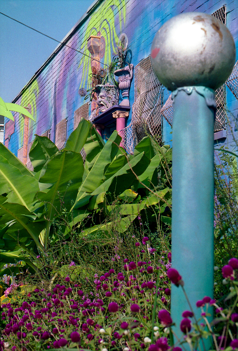
The amazing Urban Nirvana was the studio, gallery, and gardens of artist Christine Sibley. This technicolor oasis was located at the corner of DeKalb Avenue and Waddell Street during the 1990s. Sibley was known primarily for her pottery and also designed the decor for several Fellini's Pizza and La Fonda restaurants. These photos were taken in August 1992.


These first 8 photos were taken on the side of the building that faced DeKalb Avenue. Waddell Street is to the left.


The telephone pole in front of the building was decorated as a palm tree!


This fountain is below what must have originally been the front door of the building.


This is part of the garden behind the building. In the pens to the right were peacocks, goats and chickens.

Sunflowers were painted across the back side of the building.

Urban Nirvana was a magnet for artists and musicians and appeared on album covers and in several music videos. "Blue Garden Party" was a Super8 film that I shot there in 1992.


Atlanta band Ultrababyfat shot much of the video for their song "Twist" in the garden behind the building.


Urban Nirvana appears on the cover of Shawn's 1994 album Big Blue Sky.


All good things must come to an end. Miss Sibley was seriously injured in a near-fatal auto accident in 1998 and, after months of difficult recovery, sold the Urban Nirvana property in September 1999. Sadly, she passed away a few months later at age 51.

Urban Nirvana was my favorite place in Atlanta during the 1990s. Revisiting the site nearly two decades later was truly depressing. So what is there now? Altogether now: just what we need... MORE CONDOS! Here is the former site of the garden:
 
I try to keep an open mind when it comes to the recent rash of condominiums in Atlanta. After all, people have to live somewhere and this location is hard to beat. Maybe I'm too idealistic and critical when assessing current architectural trends, but in this case, even the owners seem to be sheepishly trying to hide this building from public view.

The telephone pole that had once been decorated as a palm tree is apparently all that remains.

The view on Waddell Street in January 2012:


View Larger Map